
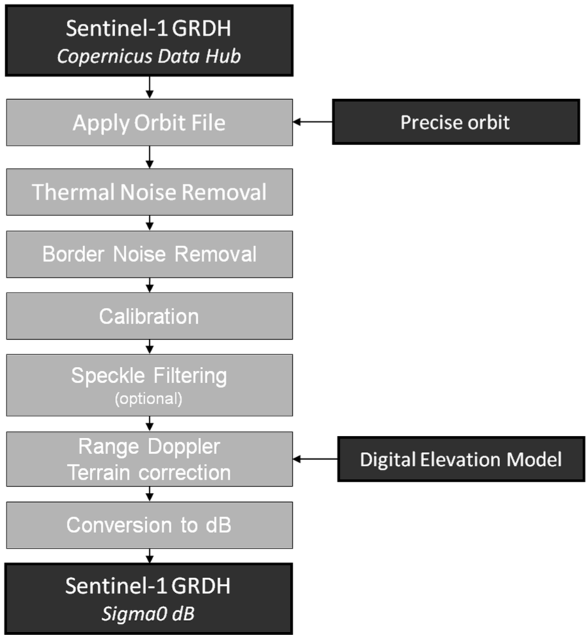
Synthetic aperture radar (SAR) image processing is a technically complex task that involves transforming raw data into usable products for specific applications, including advanced artificial intelligence (AI) systems. Due to the nature of SAR images, which are formed from reflected radar signals, processing must address challenges such as noise, geometric distortions, and polarimetric interpretation. In the following, we detail the most important technical steps in SAR image processing and their relevance to specific applications.
Conversion of raw data to radar images
SAR image processing begins with the conversion of raw radar signal data into interpretable images. This process is essential to preserve the geometric and amplitude characteristics of the observed surface. The SAR focusing technique involves a reconstruction that simulates a virtual long “aperture” by combining the radar returns from various positions of the satellite during its trajectory. To achieve this, advanced algorithms such as correlation and Fast Fourier Transform (FFT) are used, which are essential to obtain high-resolution images.
One of the key methods is Backprojection, which reconstructs SAR images by projecting the echo data onto a grid of pixels, allowing the information to be clearly visualized. On the other hand, the Range-Doppler Algorithm is used to differentiate objects in the lateral direction, taking advantage of the Doppler frequency. The Fast Fourier Transform (FFT) transforms the signals in the frequency domain, which facilitates an efficient and fast reconstruction of the images.
Geometric correction
Geometric correction in SAR image processing is essential to address the distortions inherent in this technology. SAR images can be distorted in range and azimuth, which prevents them from having an accurate projection like traditional optical images. This process seeks to transform SAR images to a standard geographic coordinate system, such as WGS84.
To achieve this, two key activities are performed: georeferencing, which aligns the image with an Earth model using GPS data and reference systems, and orthorectification, which adjusts the image to correct for distortions caused by terrain elevation using a digital elevation model (DEM). This correction is especially important in applications that require high accuracy, such as change detection in images taken at different times and infrastructure monitoring.
Filtering and noise reduction
Filtering and noise reduction in SAR images is crucial due to the presence of speckle, a type of noise that affects the visual quality and clarity of the data. This noise arises from coherent interference between radar waves reflected from various surfaces within a single pixel, making it difficult to identify important details.
To mitigate speckle without compromising essential details, advanced filtering techniques are employed. Among the most common is the Lee filter, which smooths homogeneous areas by calculating the variance within a local window. Another method is the Frost filter, which is adaptive and adjusts its behavior according to local content, preserving edges while reducing noise in uniform regions. The Gamma MAP filter is also popular for its ability to optimize the signal-to-noise ratio and maintain contrast in key image structures.
This stage is crucial for automatic object or pattern detection applications, where accurate interpretation of relative intensities is important for AI algorithms.
Radiometric correction
Radiometric correction is essential to improve the accuracy of SAR image interpretation, as the intensity of radar echoes can vary due to factors such as terrain geometry or the angle of incidence of the radar. This correction ensures that reflectivity values are consistent throughout the image, which is crucial for applications such as automatic object detection.
Two key adjustments are atmospheric attenuation correction, which compensates for the effects of the atmosphere (such as absorption and scattering of SAR signals), and angular incidence correction, which normalizes intensity variations caused by the radar’s angle of inclination with respect to the terrain. This ensures accurate interpretation of intensities, which is critical for AI algorithms that rely on an accurate reading of radiometric data in the image.
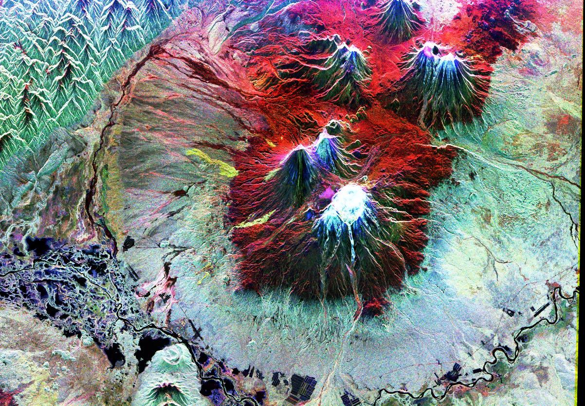
Polarimetric decomposition
Radar can transmit and receive waves in different polarizations (HH, HV, VH, VV). Polarimetric decomposition allows taking advantage of the additional information obtained by transmitting and receiving signals in different polarizations. This process analyzes the different responses of surfaces or objects in the image to extract valuable details about their structure and properties.
Among the most commonly used methods is the Freeman-Durden decomposition, which divides the signal into three key components: volumetric scattering, single scattering and double scattering, helping to more accurately characterize the observed surface. On the other hand, Cloude-Pottier decomposition, which uses coherence matrices, allows classification of the types of scattering in the scene, providing detailed information about the nature of the objects and materials present.
This type of polarimetric analysis is essential for applications such as the classification of soil or vegetation types, the identification of water bodies or man-made infrastructures, and for security and defense applications, such as the detection of unusual objects or activities in complex scenarios.
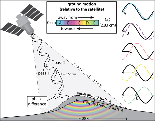
SAR interferometry
SAR interferometry (InSAR) is an advanced technique that measures small displacements on the Earth’s surface by comparing the phase of radar signals captured at different times. The key to InSAR is to generate an interferogram that reflects these phase differences between two SAR images. Effective processing requires correcting atmospheric errors using specific modeling and post-processing techniques. Then, the Phase Unwrapping algorithm translates these differences into quantifiable displacements, allowing millimeter deformation data to be obtained.
InSAR is crucial in monitoring tectonic movements, ground subsidence and structural deformations. It can also be integrated with AI systems to predict infrastructure risks, providing early warnings of potential structural failures or natural disasters.
Multisensor fusion
Multi-sensor fusion combines SAR imagery with other data sources, such as optical or hyperspectral imagery, to improve the accuracy and richness of the information obtained. This process involves advanced alignment and registration techniques to ensure that data from different sensors are perfectly synchronized and aligned.
The fusion process can be performed at several levels. At the pixel level, signals captured by different sensors are directly combined at each pixel, providing an image enriched with complementary details. At the feature level, key attributes are extracted from each image, such as textures or edges, and then fused to improve object or pattern identification. Finally, in decision-level fusion, the results of different algorithms that analyze the images separately are integrated, combining their findings to obtain a more complete picture.
Multisensor fusion is crucial in AI systems, as it allows to take advantage of the best from different data sources. This approach improves the robustness and accuracy of models, especially in multispectral scenarios or with varying visibility conditions.
Deja una respuesta