Our History
Project Evolution
1.
SEDA Launch
Creation of a Satellite AI Platform
The SEDA project originated from the 2018 call of the COINCIDENTE program, which aimed to develop intelligent systems for the exploitation of satellite data applied to military defense. SEDA focuses on the creation of a geospatial intelligence platform that uses artificial intelligence to manage and analyze large volumes of satellite data. This approach allows for processing and merging data from satellites to detect anomalies and critical objects, facilitating decision-making in the field of national and international security.
- Launched in the 2018 COINCIDENTE call.
- Web platform for geospatial intelligence.
- Satellite data analysis with AI.
2.
Expansion and Progress
AI, Data Fusion, and Potential of Remote Sensing
As the number of satellites and the volume of data generated have increased exponentially, SEDA addresses the need for advanced tools to manage and analyze this information. The platform allows for the download and analysis of satellite or aerial data, primarily optical and radar (SAR), using Artificial Intelligence (AI) engines and obtaining information from both private and open sources. These advancements, combined with techniques of Remote Sensing, facilitate the automatic detection of key elements in images, optimizing decision-making.
- Satellite data download and fusion.
- Automatic image analysis with AI.
- Automatic report generation.
3.
Development of MADS
Maturation of the SEDA Technological Demonstrator
The MADS project was developed to enhance and mature the SEDA system, expanding its capabilities through the incorporation of new satellite data sources and advanced artificial intelligence techniques. Among its improvements, MADS includes the implementation of a REST API, AIS anomaly detection, new terrestrial and marine use cases, and the integration of Edge Computing technology (module AMIGO) to process data in real-time in a portable manner. These innovations make SEDA more flexible and adaptable, providing users with the ability to deploy SEDA according to their needs.
- Expansion of capabilities and new sources.
- Implementation of a REST API.
- Creation of an Edge Computing module.
Intelligent Automation
for National Defense
+10
SUPPORT FOR SATELLITE MISSIONS
SEDA enables the automatic download of images from more than 10 satellite missions
x10
ACCELERATION IN ANALYSIS TIME
The data analysis time is reduced by 10 times thanks to advancements in AI
+20
IMPLEMENTED AI MODELS
For different use cases, spatial resolutions, and types of images
AI for Satellite Data Exploitation
What is SEDA?
Satellites are essential for national defense infrastructure, providing vital support for navigation, communication, surveillance, intelligence, and disaster management, among other critical functions. The range of services offered by satellite missions continues to expand each year.
Satellites, drones, high-altitude unmanned aerial vehicles (UAVs), the Automatic Identification System (AIS), etc., generate a vast volume of data that often requires costly and time-consuming work by specialized personnel for analysis and extraction of relevant information. Automation and efficiency provided by recent advancements in Artificial Intelligence (AI) enable optimal management and exploitation of this data, allowing us to quickly and effectively detect, identify, and map marine, atmospheric, and terrestrial phenomena.
SEDA (Satellite Data AI) is a research and development project, funded by the Spanish Ministry of Defense, that is committed to automating the analysis of satellite data to support satellite intelligence analysts. It significantly accelerates the analysis process and report generation, while reducing the associated monetary costs.
SEDA leverages Artificial Intelligence (AI) to solve military problems within a geospatial intelligence system that combines the collection, processing, and analysis of satellite imagery. It provides support for both facilities with conventional servers in a Data Processing Center (DPC) and for an Edge Computing module (Advanced Module for AI Edge Computing, AMIGO) for onboard systems, where almost all functions can be implemented in an independent, portable, and lightweight device for use in military operations or off-grid scenarios.
SEDA can be used through its user interface or via an API, where georeferenced SAR and optical images can be ingested as local images or accessed through various external providers. AIS data is also collected from accessible sources, available for anomaly detection and enabling data fusion with SAR or optical images.
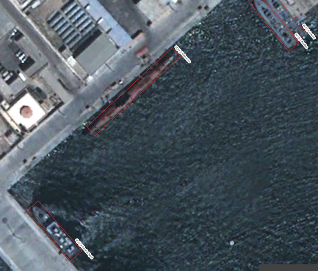
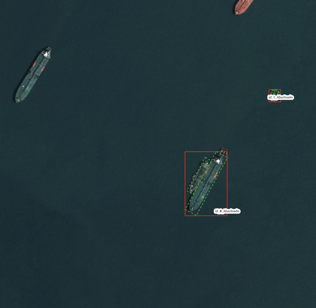
Currently, many AI-driven analyses are available, such as vessel detection and classification, along with ship detection, using different satellite missions (Pleiades, Spot, MAXAR, or Copernicus), with various types of sensors (optical or SAR) and resolutions (0.3-1m/px, 1-3m/px, or 5-15m/px). After selecting the area and dates of interest, all satellite products within that range will be available for analysis through any defined use case, displaying the results automatically and offering the option to export them in different formats, including georeferenced files or official NATO formats.