

The Importance of Satellite Images
Satellite imagery is an essential tool for understanding and analyzing our planet. From precision agriculture to climate change monitoring to military applications, these images allow us to observe the world from a unique perspective. For these images to be useful, it is essential to understand one key concept: spatial resolution.
Although there are other types of resolutions, such as the resolución temporal —which refers to the frequency with which a satellite passes over the same area—, the spatial resolution It is what defines how detailed the image we see is.
What is Spatial Resolution?
The spatial resolution of a satellite image refers to the level of detail that it can capture on a land surface. In simple terms, it is the size of the area on the ground that each pixel in the image covers. The smaller that pixel, the higher the spatial resolution, and the more detail we can see.
For example, an image with a spatial resolution of 1 metro means that each pixel in the image represents one square meter of the Earth. If the resolution is 10 metros, each pixel will cover a larger area (10×10 meters), and therefore, the image will be less detailed.
Spatial Resolution in SAR Images
SAR (Synthetic Aperture Radar) images use radar waves to capture information about the Earth's surface, allowing them to operate in adverse weather conditions and at night. Unlike optical images, spatial resolution in SAR images is determined not only by pixel size, but also by parameters such as radar wavelength and synthetic aperture size.
Spatial resolution in SAR is divided into two directions: azimuthal resolution and range resolution. Range resolution depends on the duration of the emitted pulse, while azimuthal resolution is related to the size of the synthetic antenna and the distance to the target. Thanks to advanced processing techniques, it is possible to obtain very high spatial resolutions, even in the order of meters or less, allowing to distinguish features such as vehicles, buildings and other man-made structures.
SAR imaging capabilities are critical for applications such as ground deformation detection, glacier monitoring and soil analysis, providing accurate data even in areas with persistent cloud cover or low light.
Types of Spatial Resolution
In SEDA, in addition to the distinction between optical and radar images, the following distinction of resolutions is made:
- VHR, Very High Resolution (less than 1 meter per pixel):
This category includes extremely detailed images, capable of showing small objects such as vehicles, rooftops, or even individual trees. This level of resolution is highly valued in applications such as urban planning, detailed cartography, and seguridad.
Example: Satellites as WorldView-3, which offer images with a resolution of up to 31 centimeters per pixel, make it possible to identify very specific features, such as cars on a road or even building details.
- HR, High Resolution (between 1 and 6 meters per pixel):
Here, the pixels are somewhat larger, meaning some fine detail is lost, but it is still sufficiently accurate for a wide range of applications. Medium-resolution images are useful in precision agriculture or identifying certain types of vessels.
Example: The mission satellites SPOT-6/7 they have a resolution of 1.5 meters per pixel, which is ideal for observing large crop areas and analyzing their health status or detecting changes in plant cover.
- MR, Medium Resolution (between 6 and 30 meters per pixel):
These images allow for a sufficiently detailed overview for applications that do not require an extremely high level of detail but do require analysis capabilities at a regional or local level. Although small objects such as individual vehicles or buildings cannot be distinguished, they do allow for the detection of large structures or vessels.
Example: The satellites Landsat-8 They provide images with a resolution of up to 15 meters per pixel in their panchromatic band and 30 meters in their multispectral bands, allowing the monitoring of land cover change, the identification of water bodies and the assessment of land use over large areas.
- LR, Low Resolution (more than 30 meters per pixel):
These are not of interest for SEDA applications. In this case, the images do not capture as much detail, but can cover much larger areas with a single shot. This is especially useful for global studies, such as climate analysis or observation of large ecosystems.
Example: Satellites as MODIS They capture images with a resolution of up to 250 meters per pixel, which is perfect for studying climate change or large-scale phenomena such as forest fires and droughts.
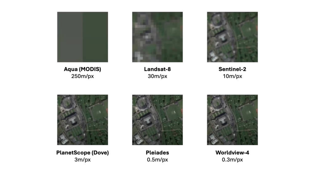
We can see an effect of different spatial resolution on an image of the same area in Figure 1, where as we increase the resolution we can observe much finer details about the content of the same.
Why is Spatial Resolution Important?
Spatial resolution determines what kind of details we can identify in an image and therefore what purposes it can be used for. For example:
- A satellite like Pleiades Neowith a resolution of 30 centimeters per pixel, it is perfect for creating detailed maps of cities, where every street, park and building can be clearly distinguished, or for classifying different types of ships according to the details identified on their decks.
- In contrast, satellites like Sentinel-2, which offer images with a resolution of 10 meters per pixel, are ideal for observing crop growth over large areas, conducting land use studies or detecting large structures or vessels.
| Spatial Resolution | Associated Satellite Missions | Key Applications |
| High – Very High Resolution | WorldView-3, GeoEye-1, Pleiades-1A/1B, Kompsat-3 | Detailed cartography, urban planning, intelligence, security |
| Medium Resolution | Sentinel-2, Landsat 8/9, RapidEye | Precision agriculture, environmental monitoring, forest management |
| Low Resolution | MODIS (Terra/Aqua), Suomi NPP, NOAA AVHRR, Sentinel-3 | Global monitoring, climate studies, ecosystem dynamics |
It is also critical to consider both the cost and availability of each satellite product. Very high resolution (VHR) imagery is the most expensive and difficult to acquire, as it is usually controlled by commercial providers and is in high demand. On the other hand, medium and low resolution imagery is significantly cheaper and often more accessible, with much available for free thanks to satellite missions from government initiatives and scientific projects.
Conclusion
The spatial resolution is a key concept in understanding satellite images. Depending on the size of the area represented by each pixel, we can obtain different levels of detail. The choice of the appropriate resolution will always depend on the type of analysis to be performed and the resources available: the more detail is needed, the higher the spatial resolution must be and the higher the associated cost.
Understanding spatial resolution allows us to get the most out of satellite imagery, harnessing its details to solve complex problems, from military applications to climate monitoring.
Leave a Reply