
SAR (Synthetic Aperture Radar) images have become an essential tool in multiple sectors, from environmental monitoring to defense and national security. This type of satellite technology offers unique advantages that make it essential for obtaining accurate data about the Earth's surface, without depending on weather or light conditions.
How do SAR systems work?
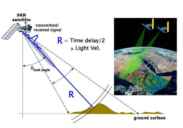
The term synthetic opening refers to a technique that simulates a radar antenna that is much larger than it actually is, allowing for improved spatial resolution of images. SAR radar emits microwave signals towards the Earth's surface. These signals interact with objects on the ground and are reflected back to the satellite. Depending on the texture, material and geometry of the terrain or object, the intensity and the time it takes for the signal to return varies, allowing for detailed images to be constructed.
One of the most interesting aspects of SAR is its ability to penetrate some surface layers such as foliage or sand, revealing hidden structures or objects. In addition, it can measure small ground displacements with high precision, which is crucial for the prevention of natural disasters and the monitoring of critical infrastructure.
Technical aspects
SAR images are suited to various applications thanks to their technical configurations. A crucial aspect in this regard is the spatial resolution, which determines the level of detail that the radar can capture. For example, when large areas need to be monitored, such as in detecting changes in land use or in monitoring natural disasters, lower resolutions can be used, ranging from 10 to 100 meters. For more specific applications, such as maritime surveillance or infrastructure analysis, medium resolutions are used, ranging from 3 to 10 meters. In cases where detailed cartography is required or where millimetric movements in the ground are to be detected, high resolution configurations are used, below 3 meters.
In addition to resolution, SAR satellites operate in different modes that impact both resolution and coverage area. In the Spotlight Mode, the focus is on a small area, providing high resolution that can reach up to 1 meter, which is ideal for detailed surveillance of infrastructures. Stripmap Modeallows you to capture larger areas, balancing detail and coverage. On the other hand, the ScanSAR Mode It is efficient for monitoring vast regions quickly, although at the cost of lower resolution.
Another important factor is the polarization. This concept refers to how radar waves interact with the Earth's surface. In the case of the Single-polarization, the radar transmits and receives in a single polarization direction, which is useful for basic studies. Dual-polarization, which captures multiple interactions of waves with the ground, offers richer information and improves data interpretation. Finally, the Quad-polarization It provides the greatest amount of information on the structure and composition of the surface, being a valuable tool in advanced scientific research.
Satellite missions with SAR technology
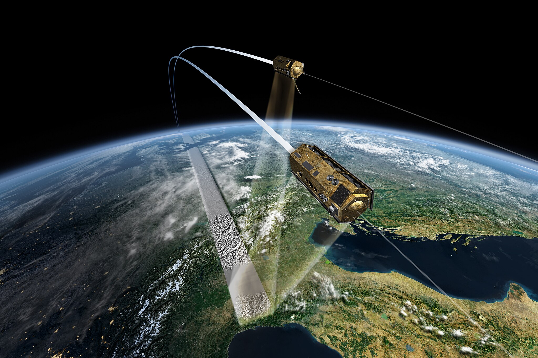
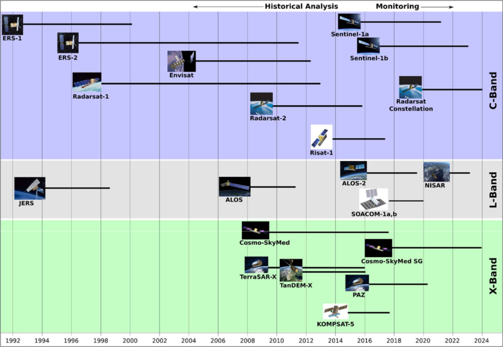
SAR technology is found on board a variety of satellite missions, each designed to meet specific needs in multiple applications. Sentinel-1, part of the European Space Agency's Copernicus programme, is a pillar of global environmental observation. Its radar images are crucial for monitoring changes in the Earth's surface, glacier melt, tides and managing emergencies such as floods.
RADARSAT-2, from the Canadian Space Agency, is specialized in monitoring polar environments. It is essential for monitoring climate change and the melting of the polar ice caps. It also provides valuable data for precision agriculture and natural resource management.
For its part, TerraSAR-X, from Germany, stands out for offering images with a resolution of up to 1 meter, making it a valuable tool for detailed mapping, monitoring urbanization and detecting ground deformations.
COSMO-SkyMed, from Italy, is a constellation of satellites that provide SAR imagery for both civil and military applications. This system is widely used in infrastructure planning, natural disaster management, and monitoring suspicious activities in sensitive areas.
Some key applications
SAR images have multiple applications that are essential in different sectors. In the environmental fieldthese images are used to assess the impact of climate change. They allow us to observe phenomena such as glacial melting, coastal erosion and deforestation. Thanks to their continuous use, authorities can track changes in land use, water bodies and ecosystems, facilitating informed and timely decision-making.
In the field of security and defenseSAR radar allows monitoring of strategic areas without being affected by adverse weather conditions. This includes the detection of military infrastructure, troop movements and illegal activities at borders. In addition, SAR images are useful for geospatial intelligence, as they help identify changes in critical infrastructure and alert about potential threats.
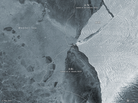
The prevention of natural disasters This is another area where SAR imagery is used. In regions prone to earthquakes, landslides and floods, they are used to monitor ground deformations and detect early signs of catastrophes. This allows for detailed, long-term monitoring of key infrastructure such as dams and bridges, providing early warnings if anomalous movements are detected.
In the agriculture and resource managementSAR images are valuable tools in precision agriculture. They allow for the creation of detailed maps of soil moisture, helping farmers to optimize irrigation decisions and monitor crop growth. This not only improves productivity, but also reduces costs.
Recent innovations
Advances in artificial intelligence and machine learning are boosting SAR image analysis capabilities. Today, algorithms are being developed that allow patterns in SAR images to be automatically detected, quickly identifying relevant anomalies or changes without the need for constant human intervention. For example, SAR images are being used in conjunction with predictive models to create more accurate simulations of future events, such as the evolution of a flood, based on historical and real-time data. In addition, combining SAR with optical data and other sources allows for the creation of highly accurate three-dimensional models of terrain and infrastructure.
In conclusion, SAR technology is a relevant tool that has transformed the way we monitor our planet. Its ability to operate in any condition and obtain detailed data makes it a very valuable resource for industries as diverse as agriculture, defense, security and disaster management. With rapid technological evolution and the growing need for accurate and accessible data, SAR images will continue to play an important role in the most strategic sectors of our society.
Leave a Reply